What is geospatial science?

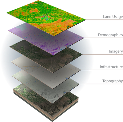
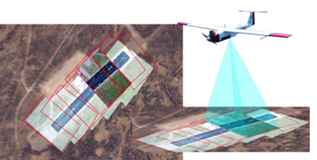
Geospatial science is a discipline that focuses on using geographic information technology to better understand physical, social, and economic processes through spatial data analyses and various forms of visualization. Technologies at the forefront of geospatial science include geographic information systems (GIS), the global positioning system (GPS), and remote sensing. These technologies have penetrated nearly every aspect of our lives including vehicle navigation, route planning, and the management and maintenance of city infrastructure, regional agriculture, and natural resources.

How we support INL

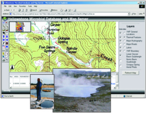
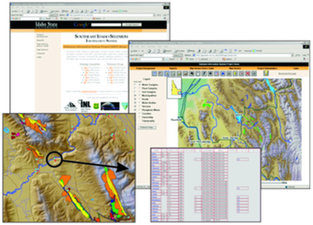
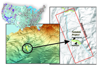
The Geospatial Science and Engineering group at Idaho National Laboratory leverages cross-cutting capabilities in Geographic Information Science (GIScience), remote sensing, database development and management, 3D visualization, GPS, software development, and web development, to provide products that support decision-makers in a variety of applications.

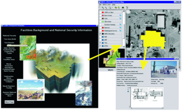
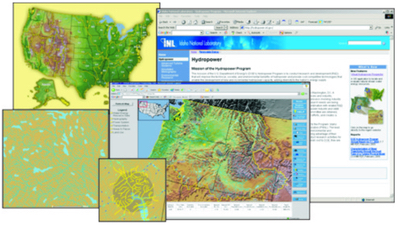
We hold degrees in GIScience, geology, hydrogeology, engineering, and environmental science. We are responsible for the development of iMap and the various specialty versions of iMap, management of Archibus and WebCentral, maintenance of the Facility Information System and all hardcopy map products. When you think of mapping, whether it's terrain, facilities, structures, earth features, or any other data that needs to be spatially displayed for analysis and planning, we can help.

What we do

The Geospatial Science and Engineering team at Idaho National Laboratory (INL) leverages cross-cutting capabilities in Geographic Information Science (GIScience), remote sensing, database development and management, 3D visualization, GPS, software development, and web development, to provide products that support management in decision-making, and help employees in their day-to-day activities.

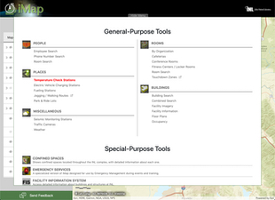
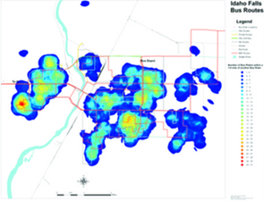
We hold degrees in GIScience, geology, hydrogeology, engineering, and environmental science. We develop various tools for facility management at the laboratory enabling them to access a wide-variety of detailed information about facilities and space usage, to plan for incoming projects and space needs. Our web-based map applications enable employees to located buildings, conference rooms, and other resources they need. And we develop specialized tools that provide advanced mapping and planning capabilities for the Emergency Services organization at the laboratory, enabling them to be better respond to any emergency situation that may arise.

With a diverse and varied background and experience base, we are able to provide unique solutions to a variety of problems.

Current Projects

Geologic Web Maps

Geologic Web Maps

The Geospatial group has developed multiple, publicly facing Web-based Mapping Applications for geologic modeling. The collaborative Regional Geology Application provides users an interactive approach to visualizing and referencing the Los Alamos National Laboratory's (LANL) Regional Geology Database. This application visualizes relevant geologic data for the DOE-NE Spent Fuel, Waste, and Storage Technology (SFWST) program. Also, the SFWST Global Site Web Map Application was developed to provide an interactive map application visualizing and referencing information for the Global Survey of Selected Deep Underground Facilities publication. Additionally, a Geology of Idaho Web Map Application was developed that provides a mashup of regional geologic databases of Idaho-relevant geologic spatial data.

Critical Infrastructure Mapping

Critical infrastructure (i.e. assets, systems, and networks) is considered vital to national and economic security. Working specifically with INL electric grid infrastructure as well as national assets, this project provides ongoing analytical and decision support for these types of systems. Specific contributions included development of a national government owned energy sector dataset for the Homeland Defense and Security community, including geolocation and attribute assignment.

Computer Aided Dispatch

INL's Emergency Response and Operations is migrating to a Computer Aided Dispatch System (CAD) that relies heavily on GIS and GPS to locate wireless calls, route emergency vehicles, visualize the location of response vehicles, and provide geospatial situational awareness of the the incident.

Bioenergy

Biofuels

The group is conducting research in conjunction with the Biofuels group to understand sustainable landscape design that will promote development of a productive, advanced biofuels economy dependent on a robust suite of lignocellulosic feedstocks; including both agricultural residues and dedicated energy crops. The work relies heavily on the approach of subfield analysis; identifying optimum areas for incorporating perennial energy crops and conservation practices into corn and soybean producing fields in a manner that is both economically and environmentally beneficial.

iMap

iMap site

iMap, our internal web-based mapping application is undergoing a complete revision and being rewritten in Angular. It will incorporate a new and fresh user-interface as well as enhanced tools. Here is a three-minute video (56.7 MB MP4) to introduce users to iMap, as well as a couple of the specific tools. The soon-to-be released iMap will appear slightly different than that in the video but will have the same, and more, capabilities.

iMap, our internal web-based mapping application, is undergoing a complete revision and being rewritten in Angular. It will incorporate a new and fresh user-interface as well as enhanced tools.


Past Projects

Western Energy Corridor

Western Energy Corridor

The Western Energy Corridor was a booklet produced by INL and energy scientists that discussed the potential natural energy resources in the western United States and Canada. This project highlighted INL's unique capabilities of providing technology that could unlock the vast potential energy reserves in the western energy corridor. The figures/maps provided in this booklet are a combination of GIS and graphic art; this combination of art and science provided a pleasing cartographic experience to the reader. The Western Governor's Association, key political leaders, and decision makers were provided with this book as a resource for potential energy growth for the region.

Electric Vehicle

INL was tasked by the U.S. Department of Energy's (DOE) Vehicle Technologies Office (VTO) to collect electric drive vehicle and charging infrastructure data for several deployment projects funded by the American Recovery and Reinvestment Act (ARRA). These projects included charging infrastructure deployments, grid-connected electric drive vehicle deployments, and deployments with both vehicles and charging infrastructure. This represents the largest ever deployment of grid-connected battery electric vehicles (BEVs), extended range electric vehicles (EREVs), plug-in electric drive vehicles, and charging infrastructure. (Resources: Electric Vehicle website)

Photovoltaic Mapper (PVMapper)

PVMapper Site Planner Interface

PVMapper is an open source GIS application for utility-scale photovoltaic (PV) project siting that optimizes site comparisons for specific users based on their own customizations of weights for specific data layers, distance, and social integration and risk tools. From a single application, PVMapper provides the most relevant GIS data layers and a "scoreboard at-a-glance" interface for users to simultaneously compare multiple sites. With the simple click of the mouse, PVMapper also provides both summary and detailed reports of siting analysis that detail scoring and the source of specific data layers and functions for easy reference. (Resources: Final Report, Poster, PVMapper website)

Pacific Northwest Regional Collaboratory

Pacific Northwest Regional Collaboratory

INL researchers developed water resource management decision tools capable of analyzing and integrating remotely sensed imagery and environmental management information to predict stream flow in snow­dominated basins.

Non-Image Sensor Integration

Non Image Sensor Integration

INL has demonstrated the ability to collect non­image sensor data and integrate it with other geospatially related data to model and analyze potential scenarios. This figure shows point data collected via an Unmanned Aerial Vehicle and could indicate air­borne contaminant concentrations.

Direct Referencing System

Direct Referencing System

The Direct Referencing System (DRS) is a prototype modular sensor system that can be rapidly configured to meet specific remote sensing mission requirements while collecting the necessary information to accurately and precisely geo­ reference sensor data acquired from unmanned autonomous vehicle systems without the use of ground control points.

Yellowstone Microbial Database

Yellowstone Microbial Database

The Yellowstone National Park Microbial Database and Map Server provides scientists the ability to query hot spring features and locate physical characteristics and associated microorganisms of interest.

Selenium Information System

Selenium Information System

The Selenium Information System is a centralized data repository that combines previously inaccessible information from area­wide investigations of Selenium contamination from a web­based GIS user interface.

Hydropower Assessment

Hydropower Assessment

An analytical assessment of the hydropower potential of the U.S. was performed by utilizing Geographic Information System tools and advanced spatial analysis methodologies. The assessment results were further analyzed for development feasibility.

Transportation Routing

Transportation Routing

INL Bus Operations is being provided with routing optimization solutions that include fuel economy, increased ridership, and higher customer satisfaction by analyzing road networks, rider densities, and destinations using the latest GIS network and raster modeling tools.

Virtual Infrastructure and Site Tour System (VISiTS)

VISiTS

The Virtual Infrastructure and Site Tour System is a stand­alone GIS tool used to clearly and efficiently present and describe facility data along with natural resource data designed to provide decision makers with a comprehensive view of an area.

Virtual Hydropower Prospector (VHP)

VHP

The Virtual Hydropower Prospector is a web-­based GIS application used to locate and evaluate natural stream water energy resources in the United States.

Geothermal Resource Mapping

Geothermal Resource Mapping

INL produced geothermal resource maps as a starting point for educating individuals, energy professionals, economic development associations, and businesses about locating, developing and using potential geothermal energy resources.

Agriculture Efficiencies and Optimization

Agriculture Efficiencies And Optimization

This project uses GIS analysis and data mining techniques to determine the economically optimum recipe for variable­ rate application of fertilizers for the simultaneous production of the grain crop and the straw biomass to be used as for biofuel feedstock. This research focused on how a farmer could change agronomic practices of fertilizing small grain crops if the straw grown became a significant biofuel feedstock.

Resources

The Geospatial Science & Engineering group draws on over 40 years of combined experience to serve the needs of Idaho National Laboratory (INL). We use commercial as well as open source software to perform modeling and analysis, application development, and to generate and disseminate cartographic and 3D products. We maintain and manage over 16 TB of data, 2 production servers, 2 development servers, and 3 data servers. And we use Windows, MacOS, and Linus workstations.

The table below lists some of the tools we have and their uses.

Software Uses
ESRI's ArcGIS Suite of software, including: Desktop, Server, Pro, Portal, Network Analyst, CityEngine, 3D Analyst, Spatial Analyst, Geostatistical Analyst, and Business Analyst All GIS-related development and analysis.
QGIS, GRASS, and MapWindow These open‑source GIS tools are available and used when necessary to meet specific customer needs.
ENVI ENVI is image analysis software used to extract information from geospatial data to enable better decision making.
R R is an open source programming language and environment for statistical computing and graphics.
GeoServer GeoServer is an open source server using open standards set forth by the Open Geospatial Consortium (OGC) for sharing geospatial data.
Equipment Applications
Large format printer One of our services is the printing of large full‑color maps of the various INL facilities. These are used by managers and adminsitrators to plan and track various resources under their purview.
Two, Trimble Geo 7X handheld GPS units We use these for high-accuracy location in various activities across the 890 sq. mi. laboratory. This includes our archaeological work, new facility location studies, and wildlife monitoring. All post-processing is done in‑house and data is ready in minutes.
RIEGL VZ-1000 Long Range Terrestrial Laser Scanner This long-range scanner can reach out to 1400m and produce high‑resolution xyzrgb point clouds. We use it for mapping the terrain for varioius land studies, help in the planning of new facilities, and in archaeological studies.
3D Mini CAVE, 3D Full Immersion CAVE, and IQ Station The CAVE (Computer Assisted Virtual Environment), allows for immersive 3D dataset navigation for various types of data analysis and dissemination. The IQ (Inexpensive Immersive Interactive Interface) Station (aka Visulalization Station) allows the user to visualize their model in 3D.
Various computing resources including: workstations, servers, and access to INL’s high-performance computing resources. Our development and analysis requires multiple platforms to achieve optimum results for any specific project.

Team

Photo of Glenn Russell

Glenn Russell

Geographic Information Scientist

Photo of Christopher Forsgren

Christopher Forsgren

Geographic Information Scientist

Photo of Tess Gardner

Tess Gardner

Geographic Information Scientist

Contact Information

For information about the iMap application or to talk about how we can help your project.
Glenn Russell
208.526.1584
Send a note

For information about what we do, or how we can work together, please contact:
Glenn Russell
208.526.1584
Send a note